Urban Geophysical Surveys
Modern cities are built on layers of history, infrastructure, and complex ground conditions that aren’t visible from the surface. Urban geophysics provides a non-intrusive way to understand what lies below—delivering critical subsurface insight before design, redevelopment, or asset management decisions are made.
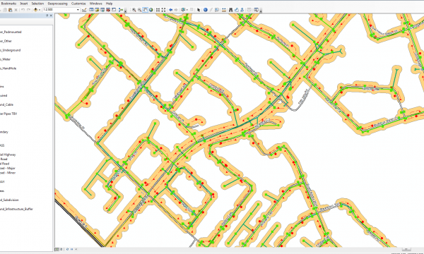
Our geophysical surveys are project-specific, not one-size-fits-all. We apply the right combination of technologies to suit the site, ground conditions, and objectives. In dense urban environments, this often means integrating multiple methods to accurately characterize subsurface materials, utilities, structures, and geological features—while minimizing disruption at street level.
Urban geophysical methods are used to support a wide range of applications, including:
- Mapping buried infrastructure and subsurface features
- Identifying changes in soil properties and fill materials
- Assessing bedrock depth and subsurface stratigraphy
- Locating voids, anomalies, and areas of concern beneath paved or developed surfaces
- Supporting environmental, engineering, and planning investigations
Because these technologies are non-destructive and can be deployed efficiently in constrained spaces, they are ideally suited for active city environments, where access, safety, and continuity of operations matter.
By translating complex subsurface data into clear, actionable insight, urban geophysical surveys help reduce uncertainty, inform smarter decisions, and provide confidence before work begins—without excavation, disruption, or guesswork.
When it comes to data collection and analysis, multiVIEW leverages the most advanced technology on the market and provides very high quality deliverables. I found their staff members to be supportive throughout the project and would recommend multiVIEW to any organization in need of geophysical services.
Matt McCullough, Regional ManagerPOLY-MOR Canada Inc.Our Geophysics services also include:
A solution to every geophysical challenge
We work with our clients to uncover the most efficient and cost effective environmental engineering solutions for soil and water contamination management, waste disposal, environmental protection and sustainability. Our Geophysics services include applying direct current resistivity, electromagnetics and seismic to locate drilling targets for groundwater supply, estimate the depth of water tables, locate groundwater wells, detect contamination and more. By quickly and accurately targeting areas of concern, you can focus your sampling investigation and spend your exploration budget wisely.
We’ll also apply techniques including Induced Polarization and Ground Penetrating Radar to mineral exploration, geological engineering and archaeological investigations. Defining base rock stratigraphy and the physical properties of soil are all a part of our site assessment services.

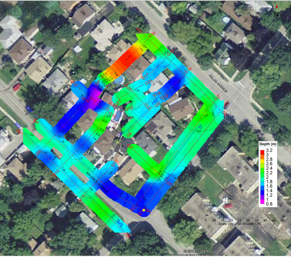
Example of 3D Intersection Imaging Taipei – Identifying Chambers:
Engineering Geology – uncovering hazards before they become liabilities
Engineering geology is dedicated to the investigation of potential hazards that can affect the location, design, construction, operation and maintenance of engineering works. We recommend performing geophysical investigations during the design stage of every geological engineering and construction project. This includes geophysical investigations for environmental impact analysis, engineering design, construction and post-construction phases as well as the inspection of existing projects.
We provide data that allows engineering firms to better understand how geological, hydrogeological and environmental conditions impact existing structures and interact with the surrounding environment, to guard against property damage and life threatening events.
Our Geophysics services include:
- Contaminant plume mapping, contaminated soil conditions mapping, water concentration and salt contamination, hazardous waste sites and sanitary landfills
- Underground storage tank (UST) detection, buried metal objects detection, abandoned well casing detection, mineshafts & mine workings mapping, site remediation and assessment, landfill mapping, tree root imaging, ancient underground foundations, graves and burials, archaeological artifacts
- Geotechnical foundation integrity & stability, loading capacity estimation, shear wave velocities analysis, compaction monitoring, geotechnical engineering investigations for dam and retaining walls, embankments, tunnels, dikes, channels, reservoirs, mining and construction works
- Bedrock depth, rippability assessment, cavity and subsidence zone detection, void detection, buried alluvial channel mapping, rock weathering analysis, geologic hazard identification, lithological mapping, thickness of overburden, fault and geological contacts mapping, subsurface stiffness, NBC seismic site classification (vs30), subsidence and channeling imaging
- Hydrogeological investigations, seepage in dam and reservoirs, groundwater well location, groundwater flow velocity and direction
An example of sinkhole imaging with Ground Penetrating Radar (GPR):