
multiVIEW Celebrates 30 Years of Utility Engineering & Geophysics
This year, multiVIEW celebrates a milestone birthday after three decades of providing utility locating and geophysics services throughout Ontario. And wow, have we seen a lot of changes over the years!
Some of these changes created both growth and new opportunities for our company along the way. About 10 years ago, demand for Subsurface Utility Engineering (SUE) became a common staple of municipal contracts. multiVIEW had been practicing Subsurface Utility Engineering and Mapping since the early days, before it became a recognized practice in Ontario. By the time that the CI-ASCE 38-02 Standard became prevalent in the province, multiVIEW’s SUE/SUM services were already aligned with its’ guidelines.
Then, in 2012, Ontario introduced groundbreaking legislation that made it law for contractors to arrange a utility locate prior to excavation. This created rapid growth within both the private and public locating space. In response to this growth, multiVIEW established a new office in Ottawa, followed by London and Kitchener. This allowed the company to mobilize quickly to meet contractual requirements and seamlessly service customers.
Where it all began
In the beginning, multiVIEW was a full service geophysics company that had evolved from the consulting division of A-Cubed Inc.: an organization founded in the early 80s that specialized in the development of new airborne Electromagnetic (EM) and Ground Penetrating Radar (GPR) systems.
At the time, multiVIEW focused on applying geophysical techniques to solve geotechnical and environmental challenges. These techniques included seismic reflection/refraction, borehole geophysics, time domain electromagnetics, frequency domain electromagnetics, among others.
Over time, the application of these techniques began to gain popularity within urban spaces, for example, to scan concrete or locate complex buried utilities. As an industry innovator, multiVIEW helped pioneer these early applications of GPR for concrete scanning.
Despite diversifying services over time, the company’s geophysical roots remain intact. multiVIEW still offers a robust range of geophysical services and our geophysics department plays a lead role in overseeing quality management throughout every area of the business.

In the early days, multiVIEW focused on applying geophysical techniques to solve geotechnical and environmental challenges. Pictured here, Ground Penetrating Radar (GPR) is applied to image the side of a mining cave, circa early 90s.
Our work took us as far and wide as Botswana, Ecuador, Chile, Moscow and many other places across the globe.

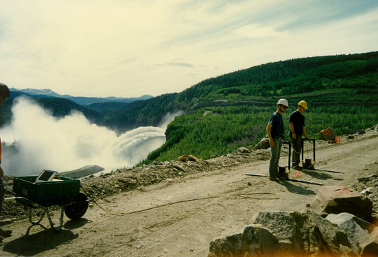
Over time, the application of geophysical techniques gained popularity within urban settings. Pictured here, multiVIEW supports road construction in Brampton, Ontario, 1993.
Where we are today – utility locating and geophysics
Today, multiVIEW focuses on helping customers solve a range of complex challenges, and has added to its portfolio of services in order to accomplish this. Utility locating and geophysical services are now complimented by offerings that include NASSCO-certified CCTV Sewer Inspection.
NASSCO sets the North American standard for sewer inspection practices, and multiVIEW is qualified to inspect mainlines, laterals and manholes. With 20% of municipal water, storm water and wastewater infrastructure across Ontario in poor or worse condition, regular inspections have become crucial to managing risk and prioritizing asset maintenance/replacement.
Another added service area includes ticket look up and screening. multiVIEW has established one of the province’s most comprehensive 24/7 ticket screening centres. The centre processes hundreds of thousands of Ontario One Call excavation requests annually, helping customers save money. By analyzing and accurately clearing tickets, customers typically see a 20%-25% reduction in costly field visits.

Today, multiVIEW offers a diverse range of utility locating and geophysical services in addition to staffing one of the most comprehensive 24/7 ticket look up & screening centres in Ontario.
Guiding principles
While diversifying services and expanding geographic territory, multiVIEW has always stayed true to core values that were established at the company’s inception – Safety, Quality & Customer Excellence.
Commitment to these values is realized in several ways. We’ve always invested heavily in training and our Technicians are some of the most highly qualified in the industry. In addition to a rigorous internal training program, Technicians progress through Damage Prevention Technician (DPT) training, and various other post-employment certification programs.
There’s a big focus on safety training – Confined Space Entry (CSE), Confined Space Rescue (CSR), Working at Heights, just to name a few, and all employees abide by the company’s Health, Safety & Environment (HS&E) Manual and Quality Management System (QMS) which are updated annually.
We’re also passionate about spreading Safety awareness outside of the company, to help others within the industry stay up to date on the latest requirements and legislation. We do this by actively participating in the damage prevention community through organizations including the American Society of Civil Engineers (ASCE), the Utility Engineering & Surveying Institute (UESI) Ontario GTA Chapter, the Ontario Regional Common Ground Alliance (ORCGA), the Association of Ontario Land Surveyors (AOLS), among many others.
Looking to the future, we’re excited to see the industry changes that will occur over the next 30 years. We also look forward to continuing to grow, evolve and help our customers succeed.

