Background
An engineering firm retained multiVIEW to perform a geophysical survey. The primary objective was to complete an electromagnetic survey in an area that has exhibited very high pH readings in surface water and groundwater, with the aim of possibly defining spatial limits to these high pH areas.
The information was used by the engineering firm to assist with their investigation of the property. The area under investigation was in the process of being decommissioned. The area was an open field covering approximately 2 hectares, located east of former lime kilns.
The site contained rail lines trending east-west through the south and central portions of the area. Plastic and metal pipelines approximately 50 cm in diameter trended east-west through the northern part of the survey area.
Methodology – decommissioned land
Survey grids on 5 metre centers were installed across the survey area site using survey tapes, a right angle prism and line-of-site positioning. A reconnaissance-level survey was performed in all accessible areas. The electromagnetic data was acquired at a station spacing of approximately 2 metres along lines spaced at 2 metre intervals.
Findings
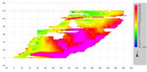
Figure 1 shows strong apparent conductivity values (often exceeding 200 mS/m) in the central portion of the survey area. The strongest conductivity areas were coincident with the location of large soil/fly ash piles; high conductivity plumes appeared to trend southward from each of the large soil piles.
The in-phase readings (Figure 2) show isolated occurrences of metal features; the broad, high in-phase zones in the central property area are due to the extremely high conductivities (in-phase readings tend to ramp up significantly in areas where the conductivity exceeds 100 mS/m).

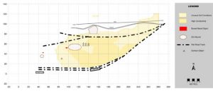
Figure 3 shows the interpretation for the area.