
Challenge
multiVIEW was retained to determine the topographic contours of the bottom of a pond in Brampton, ON using Ground Penetrating Radar (GPR). The main objective of the investigation was to assist the ongoing bathymetric survey by estimating bottom elevations, and mapping underground features from the surface of the ice.
Solution – Ground Penetrating Radar
multiVIEW leveraged a Noggin Smart Cart Ground Penetrating Radar (GPR) unit to complete the investigation. A survey grid of approximately 115 x 65 metres was established within the project area. The lines were strategically positioned to accommodate melting ice at the edge of the pond. All grid lines were established and scanned at 5m line intervals in both North and East directions. The survey grid was also superimposed on a topographic map and Google Earth imagery. The grid layout was completed using commercial measuring tapes and line of sight positioning. GPS coordinates were measured during the survey execution to support the creation of maps and referencing.
Geological features and buried objects were recorded by the GPR instrumentation, resulting in the real-time interpretation of subsurface features to a depth. Anomalies deep below the surface were identified by examining the subsurface electromagnetic reflection characteristics. These characteristics included continuous anomalous trending and high amplitude hyperbolic reflection identification.
Results
Results of the survey were presented as plan maps and in sectional views (distance vs. depth profiles) which were extracted from the raw data. The inferred location of all GPR features and interpreted anomalous zones were documented and transferred to digital drawings. Detailed plan maps illustrating the interpreted GPR anomalies associated with underground features were presented in a Geophysical Report. Data interpretation and compilation was completed by comparing the characteristics of the acquired profiles to in-house examples and results acquired from historic field surveys.
Upon integrating and examining the data, it was determined that one distinct horizontal layer from the interface of the water and lake bottom was present in the raw data from approximately 0.90m and at 1.30 depth respectively.

Ground Penetrating Radar (GPR) Profile Data: One distinct horizontal layer from the interface of the water and lake bottom was present in the raw data from approximately 0.90m and at 1.30 depth respectively.
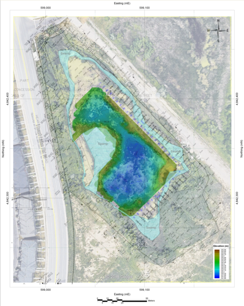

Elevation Contour Grid Map: The client was provided with a Geophysical Report that included a number of plan maps and sectional views. The investigation determined that one distinct horizontal layer from the interface of the water and lake bottom was present in the raw data from approximately 0.90m and at 1.30 depth respectively.