Leveraging Cutting Edge Utility Locating Technology:
One of the biggest changes the construction industry has seen over the last two decades is a shift towards relying on technology to enhance construction safety, avoid cost overruns and assist with decision-making. Advances such as big data, drone surveying, 3D printing and Building Information Modelling (BIM) have created a wave of innovation; allowing projects to be completed smarter, with more upfront insight than ever before. In the Utility Locator space we’re taking advantage of cutting edge utility locating technology to provide better service and products to our customers.
Here are just a few ways that we are leveraging technology to enhance our workflow and optimize customer deliverables:
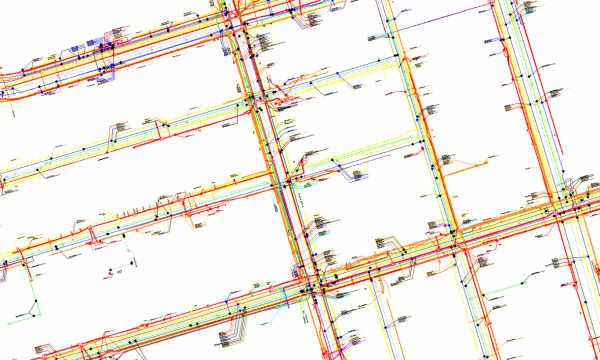
- When a higher degree of accuracy is required for collected data, or in areas where GPS is ineffective, we leverage Trimble’s Robotic Total Station (RTS). RTS increases field efficiency as it maintains a consistent lock with the mobile data collector which enables seamless field data collection. It is incorporated with the Subsurface Utility Engineering (SUE) process for surveying utility line work and appurtenances which transforms real-life physical data into a geodetic digital format. This digital data is then uploaded into a CAD package, automatically aligned onto our Customer’s base map and presented as a 2D or 3D model. It can also be referenced as a Geographic Information System (GIS) model through Esri’s ArcGIS software.

- Using Esri’s ArcGIS Desktop, we integrate and display shape files on maps and create .gbd databases for larger quantities of data. In doing so, we can create utility maps that are leveraged by our Utility Locators to assist with and verify locates. The utility maps are either stored locally on the user’s mobile-enabled laptop or accessed remotely via a published web-based map using Esri’s ArcGIS Online. This ensures that information our Utility Locators rely on is up-to-date and accurate, promoting a more efficient workflow.

- To seamlessly manage locate tickets, we leverage a combination of Synergy ERP software from Exact Globe and UtiLocate from ComPeters Inc. The integration of these two platforms allows us to effectively manage locate requests, customer data, dispatch details and billing information. The current Synergy ERP system is an effective dispatch and reciprocal communication platform, allowing communications, service requests, quality investigations, customer communications, and more, to be collected and categorized under coding criteria and the customer account number. UtiLocate also incorporates a comprehensive 360 degree feedback tool that supports efficient customer communication.

- multiVIEW field and office staff are fully qualified to collect and reproduce field utility information using a variety of platforms, including UtiLocate Draw, Microstation V8i, AutoCAD 3D and Esri’s ArcGIS software. This range of technical capabilities means that deliverables can be fully customized to specific project requirements, and are always highly visual and informative.

>>Learn more about utility locating and geophysical technology