
Background
multiVIEW conducted an investigation of Highway 401 near Toronto, Ontario in order to determine construction practice zoning. Historical records of construction and repair did not exist or were hard to locate. The objective of the RoadMap GPR survey was to assess subsurface conditions over vast lengths of road.
Methodology – Determining Construction Practice Zoning
High-speed, ground coupled ground penetrating radar data was captured and analyzed to generate automated zoning and feature classification schemes. The reduced data were placed in the RoadMap Sectional Evaluation (ROSE) Database and used to create summary reports, such as, statistical summary tables and electronic files for import in PMS and GIS systems.
Findings
In Figure 1 the automated zoning display at the top shows where unusual features occurred. The discontinuity indicator, identified zones that required further study.
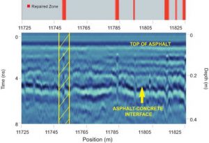
RoadMap Analysis was used to zoom-in on critical areas.
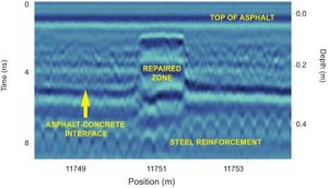
Figure 2 provides a zoom-in (on the feature at 11750m in Figure 1) which shows a former repair zone that was overlain by newer asphalt.